Monday, April 30, 2012

NEEMO 16 – ESA In search of an asteroid

Earlier this year, ESA Astronaut Samantha was fortunate enough to be assigned to NASA’s Extreme Environment Mission Operations (NEEMO) 16th mission to an underwater habitat called ‘Aquarius’, which lies about 20m under the ocean and nearly 8 miles off Florida’s Key Largo coast.

Over the years, NEEMO missions have been used by NASA to provide vital research and development data to support future exploration missions.

Living underwater is an excellent space analogue, the crew can practice EVA (‘spacewalk’) techniques using neutral buoyancy in water, whilst Aquarius offers an environment similar to a spacecraft: confined living space, total reliance on life support systems and no option for a quick return.

The crew can only surface safely after 12 hours of decompression – to do otherwise would risk severe decompression illness or ‘the bends’.

The NEEMO 16 crew comprises NASA astronaut and mission commander Dorothy (Dottie) Metcalf-Lindenburger, JAXA astronaut Kimiya Yui, Professor of Astronomy Steve Squyres and Astronaut Samantha herself.

In addition, they will be supported by two habitat technicians who are also diving experts. The crew will spend 12 days living in Aquarius, conducting two EVAs each day.

Like any space mission, there will be an experienced ground support team who will manage operations, communications and logistics from their Mission Control Centre (MCC) on dry land.

To read the full ESA blog entry click on this link.

NASA James Webb Space Telescope: Testing in Space Environment Simulator

Several critical items related to NASA's next-generation James Webb Space Telescope currently are being tested in the thermal vacuum test chamber at NASA's Goddard Space Flight Center, Greenbelt, Md.

This image shows the Optical Telescope Element Simulator, or OSIM, wrapped in a silver blanket on a platform, being lowered into the Space Environment Simulator vacuum chamber via crane to be tested to withstand the cold temperatures of space.

Image Credit: NASA/Chris Gunn

India has all the building blocks for an anti-satellite capability - Interview

Days after the milestone first test of India's strategic ballistic missile Agni-V, Scientific Adviser to the Defence Minister Dr Vijay Kumar Saraswat sat down for a detailed interview with Senior Editor Sandeep Unnithan.

The DRDO chief explains why the missile is a technological breakthrough and how it gives India the capability to target satellites in space.

Why is the Agni-V different from the previous Agni missiles?

Dr. VK Saraswat
Dr. VK Saraswat during an interview with India Today. Photo by T. Narayan.
VKS: Agni-V is a completely new missile system. It is a 21st-century missile because of the technologies used and a game changer because of its strategic deterrence value. The missile went from drawing board to launch pad in just over three years. The government sanctioned the Agni-V project in December 2008. We began design work on it in April 2009. The missile was on the launch pad on March 14, 2012 and launched five days later.

"India has all the building blocks for an anti-satellite capability" : India News - India Today

Yosemite: Timelapse photograpy

Sunday, April 29, 2012

NASA Orion Vehicle: Animated video shows spacecraft in orbit

NASA may have pushed back the Orion spacecraft's test flight to 2014, but you can get an early glimpse of the capsule in orbit thanks to this animated video from Full Werks studio.

You'll see the capsule circle the planet before touching down in the Pacific, all with a much better view than you can expect when that actual launch date rolls around.

The animation features audio clips from the original Apollo and, as any NASA-related video worth its salt should, includes a vintage voiceover from space sage Carl Sagan.

NASA Expedition 30 Commander Dan Burbank's safe Return

Expedition 30 Commander Dan Burbank smiles as he rests outside the Soyuz TMA-02M Capsule just minutes after he and Expedition 30 Flight Engineers Anton Shkaplerov and Anatoly Ivanishin landed in a remote area outside of the town of Arkalyk, Kazakhstan, on Friday, April 27, 2012.

NASA Astronaut Burbank, Russian Cosmonauts Shkaplerov and Ivanishin are returning from more than five months onboard the International Space Station where they served as members of the Expedition 29 and 30 crews.

image Credit: NASA/Carla Cioffi 

Yellowstone 'super-eruption' less super and more frequent

The Yellowstone "super-volcano" is a little less super but more active than previously studies have shown.

Researchers at Washington State University and the Scottish Universities Environmental Research Centre say the biggest Yellowstone eruption, which created the 2 million year old Huckleberry Ridge deposit, was actually two different eruptions at least 6,000 years apart.

Their results paint a new picture of a more active volcano than previously thought and can help recalibrate the likelihood of another big eruption in the future. Before the researchers split the one eruption into two, it was the fourth largest known to science.

"The Yellowstone volcano's previous behaviour is the best guide of what it will do in the future," says Ben Ellis, co-author and post-doctoral researcher at Washington State University's School of the Environment.

"This research suggests explosive volcanism from Yellowstone is more frequent than previously thought."

The new ages for each Huckleberry Ridge eruption reduce the volume of the first event to 2,200 cubic kilometers, roughly 12 percent less than previously thought. A second eruption of 290 cubic kilometers took place more than 6,000 years later.

That first eruption still deserves to be called "super," as it is one of the largest known to have occurred on Earth and darkened the skies with ash from southern California to the Mississippi River.

By comparison, the 1980 eruption of Mount St. Helens produced 1 cubic kilometer of ash. The larger blast of Oregon's Mount Mazama 6,850 years ago produced 116 cubic kilometers of ash.

The study, funded by the National Science Foundation and published in the June issue of the Quaternary Geochronology, used high-precision argon isotope dating to make the new calculations.

The radioactive decay rate from potassium 40 to argon 40 serves as a "rock clock" for dating samples and has a precision of .2 percent. Darren Mark, co-author and a post-doctoral research fellow at the SUERC, recently helped fine tune the technique and improve it by 1.2 percent, a small-sounding difference that can become huge across geologic time.

"Improved precision for greater temporal resolution is not just about adding another decimal place to a number, says Mark. "It's far more exciting. It's like getting a sharper lens on a camera. It allows us to see the world more clearly."

The project asks the question: Might super-eruptions actually be products of multiple, closely spaced eruptions through time? With improved temporal resolution, in times to come, maybe super-eruptions will be not quite so super.

More information: doi:10.1016/j.quageo.2012.01.006

Provided by Washington State University

Friday, April 27, 2012

NASA/ESA Hubble Image: Egg Nebula - the Realm of a Dying Star


Image Credit: ESA/Hubble, NASA


The NASA/ESA Hubble Space Telescope has been on the forefront of research into the lives of stars like our sun.

At the ends of their lives, these stars run out of nuclear fuel in a phase that is called the preplanetary or protoplanetary nebula stage.

This Hubble image of the Egg Nebula shows one of the best views to date of this brief, but dramatic, phase in a star’s life.

During the preplanetary nebula phase, the hot remains of an aging star in the center of the nebula heat it up, excite the gas and make it glow over several thousand years.

The short lifespan of preplanetary nebulae means there are relatively few of them in existence at any one time.

Moreover, they are very dim, requiring powerful telescopes to be seen. This combination of rarity and faintness means they were only discovered comparatively recently.

The Egg Nebula, the first to be discovered, was first spotted less than 40 years ago, and many aspects of this class of object remain shrouded in mystery.

At the center of this image, and hidden in a thick cloud of dust, is the nebula’s central star. While scientists can’t see the star directly, four searchlight beams of light coming from it shine out through the nebula.

Researchers hypothesize that ring-shaped holes in the thick cocoon of dust, carved by jets coming from the star, let the beams of light emerge through the otherwise opaque cloud.

The precise mechanism by which stellar jets produce these holes is not known, but one explanation is that a binary star system, rather than a single star, exists at the center of the nebula.

The onion-like layered structure of the more diffuse cloud surrounding the central cocoon is caused by periodic bursts of material being ejected from the dying star. The bursts typically occur every few hundred years.

This image is produced from exposures in visible and infrared light from Hubble’s Wide Field Camera 3.

NASA ISS Expedition 30 Crew Land Safely - Video


Expedition 30 Commander Dan Burbank is carried to a medical tent after being extracted from the Soyuz TMA-22 spacecraft (Credits: NASA).

ESA: Amazon Rainforest Jurua river - images

This image from the Envisat satellite shows the Juruá River snaking through the Amazon rainforest in western Brazil. 

Along the river’s main course are free-standing ‘oxbow lakes’, formed when a river changes course.

This image is a compilation of three images from Envisat’s radar, acquired on 2 January, 1 February and 3 March 2012. 

The individual images are each assigned a colour – red, green and blue – and when combined, reveal changes in the surface between Envisat’s passes.

Credits: ESA

This image from the Envisat satellite shows the Jurua River snaking through the Amazon rainforest in western Brazil. The Jurua is one of the longest tributaries of the Amazon River, flowing slowly through the half-flooded forest country it traverses in the Amazon Basin.

Along the river's main course are free-standing 'oxbow lakes', formed when a river changes course.
Tropical rainforests have some of the largest rivers in the world because of the tremendous amount of precipitation their watersheds receive.

Given its size, remote sensing is the best way to study the Amazon Basin on a large scale - especially for assessing the extent and damage due to deforestation.

This image is a compilation of three images from Envisat's radar, acquired on 2 January, 1 February and 3 March 2012. The individual images are each assigned a colour - red, green and blue - and when combined, reveal changes in the surface between Envisat's passes.

Satellite radar data can be exploited to map forest height, 3D forest structure and their natural or anthropogenic disturbance with high spatial resolution and accuracy.

Since forests assist in removing carbon dioxide from the atmosphere, this could prove to be an important tool for assessing carbon stocks and monitoring our planet's resources.

Envisat has recently been experiencing technical difficulties. Following ten years of service, the satellite stopped sending data to Earth on 8 April. ESA's mission control is working to re-establish contact with the satellite.

Images on ESA Portal

NASA HiRISE Image: Folded Layers in Melas Chasma, Central Valles Marineris

There are folded layered deposits in the southern half of this image. How did this folding occur?

On Earth, rocks are commonly folded when deeply buried and subject to high heat and pressure, which can make any rock flow.

Such deep burial and re-exposure or exhumation, is unlikely at this location.

In general Mars has experienced much less vertical motion of geologic strata than on Earth. Another possibility is that these layers were soft and deformable near the surface, such as wet or icy sediments. There are other folded layers in the giant Hellas impact basin, such as ESP_025780_1415.

Please get out your 3D glasses for a look at the stereo anaglyph here.

Science Theme: Sedimentary/Layering Processes

NASA Space Shuttle Enterprise: Fly-by in Manhattan

The Space Shuttle Enterprise flies over the Hudson River in Manhattan

NASA CNES Jason 1 Satellite: Returning to Service May 4 in Lower Orbit

The U.S.-French Jason-1 ocean-altimetry satellite, which was put into a safe-hold mode on March 3 after an on-board failure, is expected to return to service May 4 from a lower orbit, program managers said April 26.

The new orbit of 1,323.4 kilometers in altitude — some 12.6 kilometers lower than the former position — will permit ground controllers to operate Jason-1 until it fails completely, as this altitude is considered low enough to serve as a graveyard orbit, officials said.

The lower position means Jason-1 will not clutter the more-useful operational orbit in the event it fails without warning. It also reduces the number of years it will take before atmospheric drag pulls it into a destructive re-entry once it is retired.

Jason-1 was launched in December 2001 on what was supposed to be a three-year mission to succeed the larger U.S.-French Topex-Poseidon satellite.

Ocean altimetry’s popularity with civil and military customers has only grown since then.

Jason-2 was launched in August 2008, and has been operated in tandem with Jason-1 to increase the frequency of altimetry data returned to users. Jason-3 is scheduled for launch in 2014 and a successor satellite to that is being designed by the 19-nation European Space Agency.

The U.S.-French Jason operating team said Jason-1, whose payload instruments were switched on starting April 24 after a seven-week outage, should be able to perform partial service for at least another year.

“The move from the altimetry reference orbit has been a difficult decision to take, but it also signals the start of an exciting new chapter in the extraordinary mission of Jason-1,” the Jason-1 team from the NASA Jet Propulsion Laboratory and the French space agency, CNES, said in an April 23 message to users.

Nice but Dim: A bevy of stars found beyond our Milky Way

The Muñoz 1 globular cluster is seen to the right of the Ursa Minor dwarf galaxy in this image from the Canada-France-Hawaii Telescope MegaCam imager. Credit: Geha & Muñoz

A team of American, Canadian and Chilean astronomers have stumbled onto a remarkably faint cluster of stars orbiting the Milky Way that puts out as much light as only 120 modest Sun-like stars.

The tiny cluster, called Muñoz 1, was discovered near a dwarf galaxy in a survey of satellites around the Milky Way using the Canada-France-Hawaii Telescope (CFHT) and confirmed using the Keck II telescope, both of which are on Mauna Kea, Hawaii.

“What’s neat about this is it’s the dimmest globular cluster ever found,” said Ricardo Muñoz, an astronomer at the University of Chile and the discoverer of the cluster. A globular cluster is a spherical group of stars bound to each other by gravity so that they orbit around a galaxy as a unit.

“While I was working on the Ursa Minor dwarf galaxy I noticed there was this tiny little object close by,” Muñoz recalled. He made the discovery while he was a postdoctoral associate at Yale University.

Most globular clusters have in the range of 100,000 stars. Muñoz 1 has something like 500 stars. “This is very surprising,” he said.

“It’s ridiculously dim,” agreed Yale astronomer Marla Geha. “There are individual stars that would far outshine this entire globular cluster.” That puts Muñoz 1 head-to-head with the Segue 3 globular cluster (also orbiting the Milky Way) as the dimmest troupe of old stars ever found.

Muñoz 1’s discovery was the result of a survey done with the CFHT MegaCam imager in 2009 and 2010. It was then confirmed by spectroscopic study using the Deep Extragalactic Imaging Multi-Object Spectrograph (DEIMOS) on the Keck II telescope. The researchers will be publishing their results soon in The Astrophysical Journal Letters.

NASA ISS Expedition 30 Crew Land safely in Kazakhstan - Video


Expedition 30 Commander Dan Burbank is carried to a medical tent after being extracted from the Soyuz TMA-22 spacecraft (Credits: NASA).
The Soyuz TMA-22 spacecraft carrying Expedition 30 Commander Dan Burbank and Flight Engineers Anton Shkaplerov and Anatoly Ivanishin landed in Kazakhstan at 7:45 a.m. EDT. They undocked from the International Space Station at 4:18 a.m. EDT officially ending their stay.

The Soyuz performed a deorbit burn at 6:49 a.m. before the descent module separated from the rest of the Russian spacecraft and entered the Earth’s atmosphere. Afterward, the Soyuz deployed several parachutes, slowing its descent, and then fired three small engines to soften its landing.

How are you getting home today?

NASA - Orion Ground Test Vehicle Arrives at Kennedy

The Orion Ground Test Vehicle arrived at NASA's Kennedy Space Center Operations & Checkout (O&C) Facility on April 21. 

The vehicle traveled more than 1,800 miles from Lockheed Martin's Waterton Facility near Denver, Colo., where it successfully completed a series of rigorous acoustic, modal and vibration tests that simulated launch and spaceflight environments.

The ground test vehicle will now be used for pathfinding operations at the O&C in preparation for the Orion spaceflight test vehicle's arrival this summer. 

The spaceflight vehicle is currently being fabricated at NASA's Michoud Assembly Facility in New Orleans, La., and is slated for NASA's Exploration Flight Test, or EFT-1, in 2014.

Image Credit: NASA

NASA ISS Expedition 30 crew Departure: Hatches close on Soyuz TMA-22

The Expedition Crew 30 and 31 prior to departure.
Expedition 31 Commander Oleg Kononenko (left) and Expedition 30 Commander Dan Burbank prepare to close the hatches between the International Space Station and the Soyuz TMA-22 spacecraft. Credit: NASA

Expedition 30 Commander Dan Burbank and Flight Engineers Anton Shkaplerov and Anatoly Ivanishin have said their farewells, entered the Soyuz TMA-22 spacecraft and closed the hatches at 1:12 a.m. EDT.

They will undock from the International Space Station at 4:18 a.m. ending Expedition 30 and landing in Kazakhstan three and a half hours later.

The Soyuz will perform a deorbit burn before the descent module separates from the rest of the Russian spacecraft and enters the Earth’s atmosphere.

Afterwards, the Soyuz will deploy several parachutes slowing its descent and then fire three small engines to soften its landing in the steppe of Kazakhstan.

ESA Astronaut Luca Parmitano‏: In Training for ISS mission

ESA's Italian Astronaut, Luca Parmitano‏ (@astro_luca), in training for ISS mission at JSC Houston. Waiting in the simulation airlock, going through his spacesuit checks, prior to an EVA.

MARS: Student discovers new form of lava flow

Cooling lava on Mars can form patterns like snail shells when the lava is pulled in two directions at once. Such patterns, rare on Earth, have never before been seen on Mars. 

This image, with more than a dozen lava coils visible, shows an area in a volcanic region named Cerberus Palus that is about 500 meters (1640 feet) wide.
Photo by: NASA/JPL-Caltech/UA

High-resolution photos of lava flows on Mars reveal coiling spiral patterns that resemble snail or nautilus shells. Such patterns have been found in a few locations on Earth, but never before on Mars.

The discovery, made by Arizona State University graduate student Andrew Ryan, is announced in a paper published April 27, 2012, in the scientific journal Science.

The new result came out of research into possible interactions of lava flows and floods of water in the Elysium volcanic province of Mars.

"I was interested in Martian outflow channels and was particularly intrigued by Athabasca Valles and Cerberus Palus, both part of Elysium," says Ryan, who is in his first year as a graduate student in ASU's School of Earth and Space Exploration, part of the College of Liberal Arts and Sciences.

Philip Christensen, Regents' Professor of Geological Sciences at ASU, is second author on the paper.

"Athabasca Valles has a very interesting history," Ryan says. "There's an extensive literature on the area, as well as an intriguing combination of seemingly fluvial and volcanic features."

Among the features are large slabs or plates that resemble broken floes of pack ice in the Arctic Ocean on Earth. In the past, a few scientists have argued that the plates in Elysium are in fact underlain by water ice.

Thursday, April 26, 2012

Images from NASA's Wide-field Infrared Survey Explorer (WISE) reveal an old star in the throes of a fiery outburst, spraying the cosmos with dust.

The findings offer a rare, real-time look at the process by which stars like our sun seed the universe with building blocks for other stars, planets and even life.

 The star, catalogued as WISE J180956.27-330500.2, was discovered in images taken during the WISE survey in 2010, the most detailed infrared survey to date of the entire celestial sky.

It stood out from other objects because it glowed brightly with infrared light. When compared to images taken more than 20 years ago, astronomers found the star was 100 times brighter.

"We were not searching specifically for this phenomenon, but because WISE scanned the whole sky, we can find such unique objects," said Poshak Gandhi of the Japan Aerospace Exploration Agency (JAXA), lead author of a new paper to be published in the Astrophysical Journal Letters.

Results indicate the star recently exploded with copious amounts of fresh dust, equivalent in mass to our planet Earth. The star is heating the dust and causing it to glow with infrared light.

"Observing this period of explosive change while it is actually ongoing is very rare," said co-author Issei Yamamura of JAXA.

"These dust eruptions probably occur only once every 10,000 years in the lives of old stars, and they are thought to last less than a few hundred years each time. It's the blink of an eye in cosmological terms."

The aging star is in the "red giant" phase of its life. Our own sun will expand into a red giant in about 5 billion years.

When a star begins to run out of fuel, it cools and expands. As the star puffs up, it sheds layers of gas that cool and congeal into tiny dust particles.

This is one of the main ways dust is recycled in our universe, making its way from older stars to newborn solar systems.

The other way, in which the heaviest of elements are made, is through the deathly explosions, or supernovae, of the most massive stars.

"It's an intriguing glimpse into the cosmic recycling program," said Bill Danchi, WISE program scientist at NASA Headquarters in Washington. "Evolved stars, which this one appears to be, contribute about 50 percent of the particles that make up humans."

NASA Cassini: Snowballs caught crashing into Saturn's weirdest ring


Saturn's weirdest ring is known for its sparkling displays, but now it's been caught in the act. NASA's Cassini spacecraft has captured the first video of snowballs crashing into the planet's distant F-ring, creating a mini-jet of sparkling ice crystals.

The event was captured while Cassini was filming Saturn's moon Prometheus approaching the ring. The moon, which orbits just inside the F-ring, following an elliptical path, brushes up against it every 17 years. During its approach, it's thought to create a ripple in the icy ring's geometry which causes snowball-like pieces to break off. These icy fragments are then thought to quickly crash back into it causing a sparkling mini-jet.

Based on the video, researchers were able to calculate the orbital direction and speed of the snowballs. Results indicate that they followed a very similar orbit to Prometheus and hit at a slow speed of about one meter per second. This points to the culprit being small snowballs created during the moon's previous approach, which survived and went on to strike through the F-ring itself.

"We had seen these mini-jets right from day one but, like most things with the F-ring, it's trying to understand what you're seeing," says Carl Murray, a Cassini imaging team member based at University of London in the UK. The group has found 500 such mini-jets after looking through 25 images of the F-ring. They now plan to examine them more closely to see if they fit the same description as the one caught on film.

NASA PLANET: The Milky Way's 100 Billion Planets

This artist's illustration gives an impression of how common planets are around the stars in the Milky Way.

The planets, their orbits and their host stars are all vastly magnified compared to their real separations.

A six-year search that surveyed millions of stars using the microlensing technique concluded that planets around stars are the rule rather than the exception.

The average number of planets per star is greater than one. This means that there is likely to be a minimum of 1,500 planets within just 50 light-years of Earth.

The results are based on observations taken over six years by the PLANET (Probing Lensing Anomalies NETwork) collaboration, which was founded in 1995. The study concludes that there are far more Earth-sized planets than bloated Jupiter-sized worlds.

This is based on calibrating a planetary mass function that shows the number of planets increases for lower mass worlds. A rough estimate from this survey would point to the existence of more than 10 billion terrestrial planets across our galaxy.

The results were published in the Jan. 12, 2012, issue of the British science journal Nature.

Image Credit: NASA, ESA, and M. Kornmesser (ESO)

Asteroid Mining Venture Backed by Google Execs, James Cameron

Small, water-rich near-Earth asteroids can be captured by spacecraft, allowing their resources to be extracted, officials with the new company Planetary Resources say.
CREDIT: Planetary Resources, Inc.

A newly unveiled company with some high-profile backers — including filmmaker James Cameron and Google co-founder Larry Page — is set to announce plans to mine near-Earth asteroids for resources such as precious metals and water.

Planetary Resources, Inc. intends to sell these materials, generating a healthy profit for itself but it also aims to advance humanity's exploration and exploitation of space, with resource extraction serving as an anchor industry that helps our species spread throughout the solar system.

"If you look at space resources, the logical next step is to go to the near-Earth asteroids," Planetary Resources co-founder and co-chairman Eric Anderson reported.

"They're just so valuable, and so easy to reach energetically. Near-Earth asteroids really are the low-hanging fruit of the solar system."

Planetary Resources to Create 'Gas Stations' in Space

Planetary Resources says it has developed the first line in a family of deep-space prospecting spacecraft, the Arkyd-100 Series.

The craft is essentially a space telescope that will help scientists identify and prioritize near-Earth asteroid targets.

A company based in the northwestern United States called Planetary Resources says it plans to mine near-Earth asteroids for raw materials, ranging from water to precious metals.

Planetary Resources' co-founder Peter Diamandis is an entrepreneur, best-selling author, medical doctor and CEO of the X Prize Foundation.

Speaking at a news conference at the Museum of Flight in Seattle, Washington, Diamandis said he has wanted to be an asteroid miner since he was a teenager.

"The vision of Planetary Resources is to make the resources of space available to humanity, both in space and here on Earth, whether it's propellent from water on asteroids or strategic metals and minerals that are important to promoting and creating a world of abundance here on Earth," said Diamandis.

Company officials say resource extraction from asteroids will grow to be valued at tens of billions of dollars annually, but they stress that that kind of payday is decades away. They add that asteroid mining will provide a sustainable supply of precious metals to Earth's growing population.

Along with Diamandis, Eric Anderson is the co-founder and co-chairman of Planetary Resources.

While precious metal such as platinum would be welcome, Anderson says they also want to mine for elements found in abundance here on Earth - namely hydrogen and oxygen, which are the basis for water...and rocket fuel.

"If we're able to successfully, successfully deploy and mine for water, we're going to create a network of propellant depots, of gas stations, that literally open up the roadways to the rest of the solar system," said Anderson. "So it's going to drastically reduce the cost of deep space exploration."

Planetary Resources says it has developed the first line in a family of deep-space prospecting spacecraft, the Arkyd-100 Series. The craft is essentially a space telescope that will help scientists identify and prioritize near-Earth asteroid targets.

The company says this spacecraft will be launched in about two years. Beyond that, officials said the plan is to mass produce follow-on Arkyd-300 series spacecraft and send them off in swarms on expeditions. Planetary Resources says its mining would be done robotically.

Officials say they hope to identify asteroids to prospect within the decade.

The company's financial backers include billionaires such as Google's CEO Larry Page and Executive Chairman Eric Schmidt.

Planetary Resources counts famed film director and deep-sea explorer James Cameron as a project advisor, but some news reports have identified him as a financial backer. Cameron told VOA that his involvement in this project has been overstated in media reports.

ESA's Latest CryoSat results revealed

After nearly a year and a half of operations, CryoSat has yielded its first seasonal variation map of Arctic sea-ice thickness. 

Results from ESA's ice mission were presented at the Royal Society in London. In June 2011, the first map of Arctic sea-ice thickness was unveiled, using CryoSat data acquired between January and February of that year.

Now, the complete 2010-11 winter season data have been processed to produce a seasonal variation map of sea-ice thickness.

This is the first map of its kind generated using data from a radar altimeter at such a high resolution compared to previous satellite measurements.

CryoSat's altimeter makes precise measurements of its height above the ice by measuring the time interval between the transmission and reception of very short radar pulses.

Readings over the Arctic from October 2010 to March 2011 were processed to map the seasonal formation of floating ice.

ESA and NASA have been collaborating to perform carefully coordinated flights directly under CryoSat's orbit over the Arctic, gathering data to ensure the accuracy of the satellite measurements.

This first validated CryoSat dataset demonstrates the full potential of this innovative ice mission.

Owing to the high rate of change in the Arctic Ocean, this has a special relevance for climate change research.

Other significant results from this collaborative European mission will be presented and discussed, with perspectives from UK industrial and scientific communities.

This event is being jointly organised by ESA and the UK Space Agency as part of the wider celebration of the 50th anniversary of the UK in space.

The map, along with a full digital elevation model of Greenland and other scientific results from the collaborative European mission, were presented at the Royal Society in London.

The event was jointly organised by ESA and the UK Space Agency as part of the wider celebration of the 50th anniversary of the UK in space.

"Within the 50th anniversary celebrations of space activities in the UK, we have seen how the UK has been able to contribute to and lead in the many aspects of ESA's CryoSat mission," said David Williams, Chief Executive of the UK Space Agency.

Director of ESA's Earth Observation Programmes, Volker Liebig, outlined the dramatic effects that climate change has had on the Arctic, and how satellites have been monitoring sea-ice for over 30 years.

"In the coming years, the Arctic will become a very important geo-political region," said Prof. Liebig.

"15 to 20 per cent of the world's oil and gas reserves are expected there, and we will find shorter shipping routes as the ice melts. Satellites will play and ever-important role in the sustainable management of this sensitive region."


Every year, the Arctic Ocean experiences the seasonal formation and then melting of vast amounts of floating ice. Over the past decade, satellites have seen an acceleration in the rate of overall sea ice loss.

Radars on satellites such as ESA's CryoSat can acquire high-resolution images through clouds and darkness. This is particularly useful when observing the inaccessible Arctic, which is prone to long periods of bad weather and extended darkness.

In the coming years, CryoSat data will map precise changes in sea-ice thickness year to year, furthering our understanding of the effects that climate change has on the Arctic.

ESA's SMOS mission is providing complementary information on sea-ice cover and the thickness of thin ice.

NASA - The Sombrero Galaxy's Split Personality

Image credit: NASA/JPL-Caltech

The infrared vision of NASA's Spitzer Space Telescope has revealed that the Sombrero galaxy -- named after its appearance in visible light to a wide-brimmed hat -- is in fact two galaxies in one. 

It is a large elliptical galaxy (blue-green) with a thin disk galaxy (partly seen in red) embedded within. 

Previous visible-light images led astronomers to believe the Sombrero was simply a regular flat disk galaxy.

Spitzer's infrared view highlights the stars and dust. The starlight detected at 3.5 and 4.6 microns is represented in blue-green while the dust detected at 8.0 microns appears red. 

This image allowed astronomers to sample the full population of stars in the galaxy, in addition to its structure.

The flat disk within the galaxy is made up of two portions. The inner disk is composed almost entirely of stars, with no dust. 

Beyond this is a slight gap, then an outer ring of intermingled dust and stars, seen here in red.

NASA Dawn Reveals Secrets of Giant Asteroid Vesta - 3D

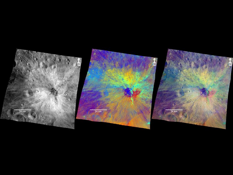
This set of images from NASA's Dawn mission shows topography of the southern hemisphere of the giant asteroid Vesta and a map of Vesta's gravity variations that have been adjusted to account for Vesta's shape. Image credit: NASA/JPL-Caltech/UCLA/MPS/DLR/IDA.

Findings from NASA's Dawn spacecraft reveal new details about the giant asteroid Vesta, including its varied surface composition, sharp temperature changes and clues to its internal structure.

The findings were presented at the European Geosciences Union meeting in Vienna, Austria, and will help scientists better understand the early solar system and processes that dominated its formation.

Images from Dawn's framing camera and visible and infrared mapping spectrometer, taken 420 miles (680 kilometers) and 130 miles (210 kilometers) above the surface of the asteroid, show a variety of surface mineral and rock patterns.

Coded false-colour images help scientists better understand Vesta's composition and enable them to identify material that was once molten below the asteroid's surface.

Researchers also see breccias, which are rocks fused during impacts from space debris. Many of the materials seen by Dawn are composed of iron- and magnesium-rich minerals, which often are found in Earth's volcanic rocks.

Images also reveal smooth pond-like deposits, which might have formed as fine dust created during impacts settled into low regions.

"Dawn now enables us to study the variety of rock mixtures making up Vesta's surface in great detail," said Harald Hiesinger, a Dawn participating scientist at Munster University in Germany. "The images suggest an amazing variety of processes that paint Vesta's surface."

At the Tarpeia crater near the south pole of the asteroid, Dawn imagery revealed bands of minerals that appear as brilliant layers on the crater's steep slopes. The exposed layering allows scientists to see farther back into the geological history of the giant asteroid.

The layers closer to the asteroid's surface bear evidence of contamination from space rocks bombarding Vesta. Layers below preserve more of their original characteristics. Frequent landslides on the slopes of the craters also have revealed other hidden mineral patterns.

"These results from Dawn suggest Vesta's 'skin' is constantly renewing," said Maria Cristina De Sanctis, lead of the visible and infrared mapping spectrometer team based at Italy's National Institute for Astrophysics in Rome.

Dawn has given scientists a near 3-D view into Vesta's internal structure. By making ultra-sensitive measurements of the asteroid's gravitational tug on the spacecraft, Dawn can detect unusual densities within its outer layers.

Data now show an anomalous area near Vesta's south pole, suggesting denser material from a lower layer of Vesta has been exposed by the impact that created a feature called the Rheasilvia basin. The lighter, younger layers coating other parts of Vesta's surface have been blasted away in the basin.

Dawn obtained the highest-resolution surface temperature maps of any asteroid visited by a spacecraft. Data reveal temperatures can vary from as warm as minus 10 degrees Fahrenheit (minus 23 degrees Celsius) in the sunniest spots to as cold as minus 150 degrees Fahrenheit (minus 100 degrees Celsius) in the shadows.

This is the lowest temperature measurable by Dawn's visible and infrared mapping spectrometer. These findings show the surface responds quickly to illumination with no mitigating effect of an atmosphere.

"After more than nine months at Vesta, Dawn's suite of instruments has enabled us to peel back the layers of mystery that have surrounded this giant asteroid since humankind first saw it as just a bright spot in the night sky," said Carol Raymond, Dawn deputy principal investigator at NASA's Jet Propulsion Laboratory in Pasadena, Calif.

"We are closing in on the giant asteroid's secrets."

Launched in 2007, Dawn began its exploration of the approximately 330-mile-wide (530-kilometers) asteroid in mid-2011. The spacecraft's next assignment will be to study the dwarf planet Ceres in 2015. These two icons of the asteroid belt have been witness to much of our solar system's history.

Wednesday, April 25, 2012

Paralysed Claire Lomas walks London marathon in Robotic Suit

Claire Lomas, paralysed in a horse riding accident, had some dashing male company as she continued her quest to complete the 2012 London Marathon yesterday.

Claire, 32, of Eye Kettleby, near Melton, is almost six miles into the 26-mile course, which she is walking in a Cyclone robotic suit, called ReWalk.

She was joined for the last mile of yesterday's leg, in south London, by former tennis ace Tim Henman and his wife, Lucy.

"I couldn't believe I was actually there with Tim Henman," said Claire.

"He was my favourite tennis player of them all and it was so strange to see him there in front of me. He's exactly like he is on the telly. I told him he used to put me through hell watching him play."

Claire, who was paralysed from the chest down in a riding accident five years ago, is aiming to complete the route in two weeks to raise thousands of pounds for Spinal Research.

She said: "It was a tiring day and I felt a little sore but having Matt and Tim walk with me really spurred me on – they are both lovely blokes."

Claire is walking in a pioneering suit using motion sensors, electronics and computers to help paraplegics walk again.

Tomorrow's leg will see her pass the Cutty Sark on her way through Greenwich.

More information can be found on her website www.get-claire-walking.co.uk

Below is a short video showing Claire training before the marathon. Other Videos uploaded by Claire can be found here: www.youtube.com/user/clairelom


NASA - Vibidia Crater in Color

These composite images from the framing camera aboard NASA’s Dawn spacecraft show three views of the comparatively fresh crater named Vibidia on the giant asteroid Vesta.

A black-and-white image that highlights topography, a colorized image that highlights composition and a combination of the black-and-white and colorized images to show the relationship between topography and composition are included here.

The impact that created Vibidia occurred at the edge of a cratered highland in the equatorial region and extends to a basin known as Veneneia. It appears to be located in a gentle depression, presumably an older crater.

Scientists think a relatively small object caused the crater, which features many boulders inside and rays of dark material. As on the moon, bright rays can be the result of compositional differences in material thrown out by the impact compared to the surrounding terrain.

Or bright rays can indicate differences in maturity -- that is, the amount of time the surface has been exposed to subsequent bombardment by micrometeoroids and cosmic rays.

Vibidia exhibits a particularly colorful blanket of ejected material, demonstrating that the surface and the layer just beneath are made up of many different kinds of materials.

These patterns reflect a complex interplay of ancient volcanic and impact processes that shaped Vesta’s crust. The impact that created Vibidia also appears to have caused an area with a width five times the diameter of the crater to collapse.

The framing camera has seven color filters that allow it to image Vesta in a number of different wavelengths of light. Being able to image in many wavelengths enhances features and colors that would otherwise be indistinguishable to the human eye.

In this colorized image, scientists assigned different color channels to specific ratios of wavelengths of radiation. In this scheme, green shows the relative strength of a particular mineralogical characteristic -- the absorption of iron.

Brighter green signifies a higher relative strength of this band, which indicates chemistry involving pyroxene. On the other hand, reddish colors indicate either a different mineralogy or a stronger weathered surface.

These images are composite images made from those taken during Dawn’s high-altitude mapping orbit (420 miles or 680 kilometers above the surface) on Oct 27, 2011. They cover an area that is about 40 by 40 miles (60 by 60 kilometers). This area is near the edge of the Rheasilvia basin in Vesta’s southern hemisphere.

The Dawn mission to Vesta and Ceres is managed by NASA's Jet Propulsion Laboratory, a division of the California Institute of Technology in Pasadena, for NASA's Science Mission Directorate, Washington. UCLA is responsible for overall Dawn mission science.

More information about Dawn is online at http://www.nasa.gov/dawn and http://dawn.jpl.nasa.gov .

Hunt is on for pieces of van-sized California meteor


Wanted: fragments of a minivan-sized meteor that exploded over northern California and Nevada on Sunday morning and may well have survived to strike Earth.

Meteorites – meteors that make landfall – can provide crucial information about the chemical composition of the early solar system.

"It's like getting sample return without having to go there," says Bill Cooke of NASA's Meteoroid Environment Office at the Marshall Space Flight Centre in Huntsville, Alabama.

However, meteorites are rare. Though meteors frequently streak across the sky, they tend to burn up before reaching the ground or they land in the sea. There's reason to think the recent meteor is different.

Apart from exploding over land, it created a sonic boom, so it must have stayed intact for long enough for it to get down into the denser air low in the atmosphere – just 16 kilometres above the Earth's surface, Cooke reckons – raising the chance that some of it hit the dirt.

Sudan similarity
He estimates it was about 4 metres long, about 70 metric tonnes and packing the energy of 4 kilotonnes of TNT. "That's about one-fourth the energy of the 'Little Boy' bomb dropped on Hiroshima," he says.

That makes the rock even bigger than 2008 TC3, a meteorite which was detected before it entered the atmosphere and became the first cosmic impact to be traced from space to landfall when astronomers found its scattered fragments in Sudan in 2008.

Cooke is also hoping someone took a video of the new meteor.

Astronomers used infrasound signals – low frequency sound that travels great distances – detected at two ground-based stations to pinpoint the spots where the new meteor entered the atmosphere and then exploded. They don't yet know where the fragments went.
National Geographic’s zoomable panoramic photos of Discovery allow you to see the instrumentation and controls required to operate the space shuttle.

The space shuttle Discovery made its last flight on Tuesday, April 17, 2012 aboard a retrofitted 747 jumbo jet through restricted airspace over Washington, D.C. with an armed escort.

Its destination was the Smithsonian National Air and Space Museum. The National Geographic site has this two-minute video of Discovery’s final flight over D.C.

Discovery will be on display but, unfortunately, it is not going to be open to the public; the Smithsonian plans to seal it up indefinitely. But before they do, National Geographic, as well as many other news organizations, was able to get inside and take pictures of the shuttle’s interiors.

National Geographic took gigapans of Discovery – a gigapan is a 360-degree photograph with the equivalent of 340 8-megapixel photos stitched together. (Gigapans technology was developed for the Mars Rovers.)

National Georgraphic took 27 gigapans of Discovery, but only 10 gigapans are currently available online; National Geographic plans to release more images on its Spaceflight HD Gigapans page in the next few weeks.

These gigapans allow you to explore online the extensive instrumentation and controls required to operate a space-faring vehicle (check out the Discovery Flight Deck gigapan, which is 2.74 gigapixels) and other areas of the ship, such as the toilet. Each gigapan contains a few “snapshots,” which are areas of interest within the photo that immediately zoom the gigapan when clicked.

Discovery’s sister ships will become museum pieces as well, with Enterprise on display in New York City, Endeavor in LA, and Atlantis at the Kennedy Space Center in Florida.

Will you travel to the Smithsonian in Washington, D.C. or another one of these cities to see a shuttle up close? Share your plans in the comments.

Also read: The NASA site overview of Discovery

Scientist unveils mind-controlled robot for paraplegics

A professor at a Swiss university on Tuesday unveiled a robot that can be controlled by the brainwaves of a paraplegic person wearing an electrode-fitted cap, news agency ATS reported.

A paralysed man at a hospital in the town of Sion demonstrated the device, sending a mental command to a computer in his room, which transmitted it to another computer that moved a small robot 60 kilometres (37 miles) away in Lausanne.

The system was developed by Jose Millan, a professor at the Federal Polytechnic School of Lausanne who specialises in non-invasive interfaces between machines and the brain.

The same technology can be used to drive a wheelchair, Millan said.

"Once the movement has begun, the brain can relax, otherwise the person would soon be exhausted," he said.

But the technology has its limits, he added. The brain signals can be scrambled if too many people are gathered around a wheelchair, for example.

Besides making paraplegics mobile, neuroprosthetics could be used to help patients recover lost senses, researchers said.

Professor Stephanie Lacour and her team are working on an "electric skin" for amputees, a glove fitted with tiny sensors that would send information directly to the user's nervous system.

Eventually, researchers say they hope to create mechanised prosthetics that are as mobile and sensitive as a natural hand, Lacour said.

Other researchers at Lausanne are working on enabling paraplegics to walk again with electrodes implanted in their spinal cords.

"The goal is that after a year of training with a robotic aide, the patient will be able to walk without a robot. The electrodes would stay implanted for life," said Professor Gregoire Courtine.

He said he is currently setting up clinical trials and hopes to run tests at Zurich's university hospital within a year.

Pakistan Test Launch Ballistic Missile

Pakistan has test fired a nuclear-capable ballistic missile, military officials say, less than a week after India also test-launched a long-range missile.

The military said the test of the Shaheen 1-A, an intermediate-range missile capable of reaching targets in India, was successful.

India and Pakistan have fought three wars since 1947.

They conduct regular missile tests and inform each other in advance.

Both countries carried out nuclear weapons tests in 1998.

Defence experts say that while the exact range of the Pakistani missile has not been revealed, it is it capable of hitting targets up to 2,500 to 3,000km (1,550 to 1,850 miles) away - putting arch-rival India well within reach.

The Agni-V long-range intercontinental ballistic missile launched by India last week has a range of more than 5,000km (3,100 miles), potentially bringing targets in China within range.

Pakistan's last test was last month, when it launched the short-range nuclear-capable Abdali missile.

The missile tested on Wednesday landed in the sea, the military said. It is a version of the Shaheen-1 - with improvements in range and technical capabilities - and is able to carry nuclear and conventional warheads.

The military say that the missile - which successfully hit its target in the Indian Ocean - further consolidates and strengthens Pakistan's deterrence abilities.

Pakistan's missile arsenal includes short, medium and long range missiles, all named after Muslim conquerors.